
Picture

Picture
Showing posts with label Maps. Show all posts

Wednesday, July 10, 2013

Family History Through the Alphabet – X Marks the Spot

For 26 weeks I will take you on a family history journey through the alphabet, one letter at a time.  I have decided that each post will be educational in nature, focusing on topics related to resources, methodology, tools, etc.  Although the challenge is complete, there are still some people who are finishing up and Alona, the host, is encouraging others to participate anyway.  Additional information on the challenge, can be found at Take the ‘Family History Through the Alphabet’ Challenge


xThis week it’s all about maps.  I love maps.  They are great tools for genealogists and often help us solve research problems.  In this post, I’ll share a few examples of how I use maps in my own research.

Plotting Land Owners

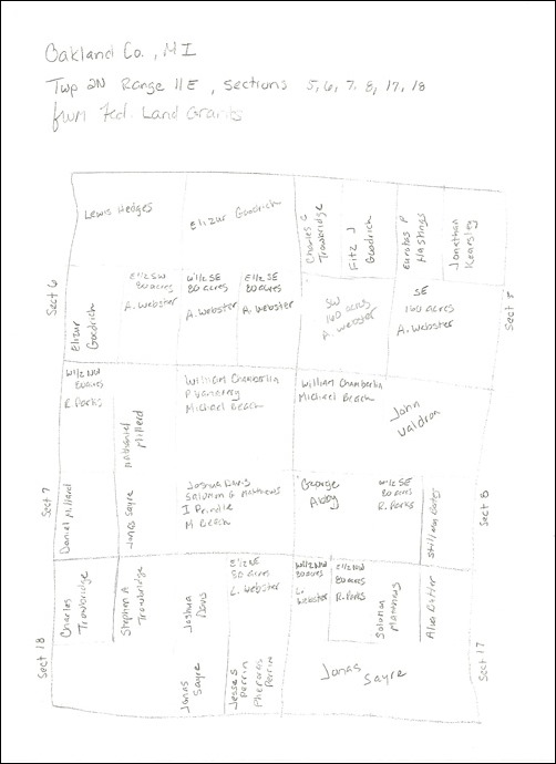
For rural dwellers, creating a map of our ancestors can be very helpful.  We can visually see what parcels of land a they owned and who their neighbors were.  This can help solve many mysteries.  For example, when I plotted out part of a township where both my fifth great-grandfathers, Aaron Webster and Robert Parks, owned land in Oakland County, Michigan, I saw several familiar surnames.  One of Aaron’s daughters married Zadock Bates and the other married Erastus or Orestes Millard.  Both of these surnames appear in close proximity to the land that Aaron owned, so it’s possible that the daughters’ spouses are related to those nearby families.  I created a map by simply drawing it out using the land descriptions for all the federal land grants in the sections I was interested in.
OC-map

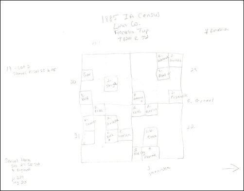
In another instance, I was trying learn the origin of an Iowa family, who had apparently previously lived in Georgia, Pennsylvania, and Missouri.  Using the 1885 Iowa census, which includes the place of birth for each person, as well as a land description, I decided to plot the family’s neighbors who were in the same place and the same time in hopes of finding connections between the families in other locations.  For example, one neighboring family had a child born in Missouri in 1874, as did my family.  While I haven’t been able to actually solve this mystery, I am hopeful that researching the neighbors further will be of help.  Again, this one is a hand-drawn map, but I only plotted families with similarities to my family (I can always go back and add in the rest).
LinnCoMap

Plotting City Residences

In addition to my rural folks, I have a lot of city dwellers, particularly in Chicago.  I use Google Maps all the time for various reasons.  For example, plotting the family on a map can help you figure out what churches to search.  I had my Ward/McMahon family mapped out for different reasons (comparing locations to other possible family members), but when the Catholic church records for Chicago became available through FamilySearch, I decided it was time to do some digging, but I had no idea where to begin. 

Looking at the map I had already created, I began to go through all of the Catholic churches listed at ChicagoAncestors and determine where each had been located and the years of operation (I could have used city directories for this as well).  Once I identified a possible church, I plotted it on the map.  If I found that an event had occurred for the family, I added the details to the map’s location description.  Here’s the map I created.  If you click through to view it on Google, you will see the descriptions of all the pins and see how I have it organized by family and year.


View Wards/McMahons in Chicago in a larger map

I’ve also used Google Maps to help with foreign research.  For example, I had some Luxembourg families that were apparently in three different communes in two different cantons.  Seeing them all on the map, I realized that they were actually pretty close to each other.


View Luxembourg in a larger map

And you can read about my map project for my Prussian research here.

Boundary Changes

Maps are especially helpful in discovering boundary changes.  These changes could be at any level, including territory, state, county, etc.  One tool that I like is AniMap.  In the following two images, you can see how the county boundaries changed for New York from 1794 to 1799 and one of the places I research belonged to two different counties, thus two different places to research.

Auburn1794

NY1799XP

Wrap Up

These are just a few examples but I hope that this post gave you some new ideas for using maps in your genealogy research.  If you’d like to share how you use maps in your own research, please leave a comment—I’d love to hear other ideas!


Share/Bookmark

Wednesday, October 3, 2012

When In Doubt, Map It

Continuing on from My Adventure With Meyers Gazetteer, I was trying to take the information that I learned and develop some sort of research plan.  Unfortunately, I didn’t get very far as I ran into a stumbling block.

Have you ever noticed that some entries in the Family History Library Catalog contain special notes?  For example, in the listing for Zivilstandsregister, 1874-1878, the note explains that these are civil registrations of births, deaths, and marriages for Damsdorf, Pommern, Preußen.  It further goes on to list the other towns that are included in these registers.  Furthermore, it also indicates that Damsdorf is now Niezabyszewo (Bytów), Koszalin, Poland.  That’s a lot of useful information.

More importantly, this added information is helpful when there is no specific location entry for the place you are looking for.  In my case, there is no location entry for Germany, Preußen, Pommern, Bernsdorf, so finding records for this location is a little difficult.  However, noting that Bernsdorf was listed in the notes section of the entry described above, I tried a “keyword” search for Bernsdorf.  There were 15 matches, one of which is the one above.  But there were two other entries related to Pommern that needed to be explored and both were more civil registrations.

The first one was quickly ruled out; the other place names that were included indicated to me (by looking at the gazetteer) that this was a different Bernsdorf altogether.  But the other entry, well there were some place names that were familiar, particularly the civil registration district of Gersdorf.  From my excursion into the Gazetteer, and taking the time to translate it, I recognized Gersdorf and the district government office for Bernsdorf.

Now, I have no idea how this government works or what each “branch” was responsible for.  I also don’t know if you can register, say births, in another location.  But I know enough to question whether the Bernsdorf in this listing is the same Bernsdorf that I’m working with.  So to Google Maps I went!


View this map in Google, which will show each place with its previous and current name.

I already knew from the FHL listing for the Damsdorf registrations, that it was now Niezabyszewo (Bytów), Koszalin, Poland, so I marked it on the map.  The same listing also included the new name of Hygendorf, so on the map it went.  The FHL listing for Gersdorf indicated that it is now Ząbinowice (Bytów), Koszalin, Poland; mapped. 

Through a variety of websites that provided the new names for all of the other towns listed in both FHL catalog entries, I was able to place them all on the map.  I color coded them so I knew which towns were in which batch of civil registrations.  And wouldn’t you know, as I suspected, Bernsdorf is right in the middle (the marker in yellow).  The civil registration office in Gersdorf is about two miles closer to Bernsdorf than Damsdorf, which is the one its assigned to.

Is it possible that some of my family’s records ended up being registered in Gersdorf?  According to the FHL catalog entry there were some from Bernsdorf, so I think it’s worth pursuing.

Had I not first deciphered the gazetteer listing, I would not have recognized the town of Gersdorf.  And, although I suspected a “border” situation, had I not mapped these locations, I would not have known to consider looking in the civil registrations for Gersdorf.  So when in doubt, map it!


Share/Bookmark

Friday, July 16, 2010

Friday Finds – 07/16/10

Weekly column sharing genealogy-related things that I’ve learned or found.

52 Weeks of Online American Digital Archives and Databases: Massachusetts – Another great guide from Miriam over at AnceStories.

Exploring Newberry's Atlas of Historical County Boundaries – Randy over at Genea-Musings shares some tips for using the Atlas of Historical County Boundaries developed by the Newberry Library in Chicago.  I' haven’t explored it too much myself, but hope to use Randy’s tips in the near future (time is certainly not permitting these days).

First up, Illinois land grant records at NARA Chicago – This post from Blog of a Genealogist In Training contains a list of Illinois land grant records available at the NARA Great Lakes Region in Chicago.


Share/Bookmark

Tuesday, February 16, 2010

52 Weeks to Better Genealogy – Challenge #7, Google Maps

This week’s challenge:

Play with Google Maps. This is a helpful tool for determining the locations of addresses in your family history. Where your ancestral homestead once stood may now be a warehouse, a parking lot or a field. Perhaps the house is still there. When you input addresses in Google Maps, don’t forget to use the Satellite View and Street View options for perspectives that put you were right there where your ancestors once stood. If you’ve used this tool before, take sometime and play with it again. Push all the buttons, click all the links and devise new ways it can help with your personal genealogy research. If you have a genealogy blog, write about your experiences with Google Maps, or suggest similar easy (and free) tools that have helped in your own research.

I use Google Maps all the time.  I have several maps that I’ve plotted my family’s residences and cemeteries.  I had mainly focused on my Chicago families, which is a difficult task since I have to convert addresses prior to 1909 in order to find the correct placement on today’s map.  Additionally, many street names have changed over the years, adding an extra step in some cases.

Since I’ve been working on my Oakland County, Michigan folks, I thought I’d do some plotting on Google Maps.  Right now, the map includes all the cemeteries were my family is buried, as well as outlines of the land my family purchased through the federal government in the 1820s.  This was the first time I’ve plotted anything from a township map on a street map.  Fortunately, I was able to find a township map online from 1990 that also included the street names, so I was able to figure it out!!

streetview

The nice thing about Google Maps is the Satellite view.  In one case, I was not able to find a cemetery because it was not labeled on the map.  All I had was a general description of where it was located.  I switched to Satellite view and was able to see the cemetery in order to plot the exact location.

satelliteview

You’re welcome to take a look at this particular map of my Family in Oakland County, Michigan, to see how I use this application.  Another map that I created to help me with my Emil MILLER research can be viewed here.  In this case, I am trying to find applicable Emil MILLER/MULLER/MUELLERs that could be my Emil.  I’ve plotted those found in the Chicago city directories in Google Maps, for those who resided close to the church were three generations passed through.  There are quite a few, but it’s helped me to narrow down the possibilities based on location to the church.

GenBlog%20Signature%5B4%5D[5]


Share/Bookmark

Friday, December 18, 2009

Diving Into Land Records, With a Splash of Webster & Parks

I’ve been spending a lot of time lately on my Oakland County, Michigan clan.  And I’ve been studying up on land records, so I thought I’d put my learnings to the test.

Since my Michigan clan had located there when it was still a territory, I figured I’d find some federal land patents for at least some of them.  So my first step was to check out the Bureau of Land Management’s General Land Office records online.  While my clan was located in other areas of Michigan, my focus was on the surnames of Webster and Parks in Oakland County, Michigan.  I found several records (with images) for those I know are related, as well as a few others that I’m not sure about at the moment.

Following the advise of Christine Rose in her book, Courthouse Research for Family Historians, I made a list of all the people I found with the surnames I was seeking, and then placed them in context on a section map.

There are 36 entries on my list.  I included the following headings:

  • Document #
  • Name(s)
  • Aliquot Parts
  • Section
  • Township
  • Range
  • Meridian
  • Issue Date

Once I had them entered, I sorted the items first by township, then by range, so I could visually see them grouped together.

spreadsheetSS
Figure 1 – Screenshot of my land listing for Oakland County, Michigan.

I then took my list and placed the names in the corresponding section on a township map.  My biggest group, with each of the two surnames, was for Township 2N, Range 11E.  It includes Robert Parks, Aaron Webster, and Luther Webster.

townshipSS
Figure 2 – Township 2N, Range 11E, Oakland County, Michigan

The close proximity of Aaron Webster and Robert Parks could explain how Aaron’s son, Calvin, and Robert’s daughter, Betsey, came together and married in Oakland County in 1825.

Next, I hand-drew the six sections that are clustered together, to see what pieces of land were owned by whom, based on the descriptions.  This gives me a better idea of how close these families were location-wise.

 section
Figure 3 – Hand-drawn map of Sections 5, 6, 7, 8, 17, 18 in Township 2N, Range 11E, Oakland County, Michigan

Here I can see that Robert Parks and Aaron Webster did not share property lines.  However, Robert did share property lines with Luther Webster, who was Aaron’s son. 

Next Steps

Most of the names on my list I recognize.  Some are common in my tree and will require further investigation as to whether or not they are related (e.g., I have several William Websters and some John Parks that could have been in the area during this time period).  There are some names I am not familiar with, but given that they are related surnames and in the same general vicinity, it’s worth looking into them.

Here’s what I plan to do next:

  • Investigate who else owned land in Township 2N, Range 11E (especially in Section 5 between Aaron Webster’s two pieces of land).  Then devise a plan to investigate local land records for these people in hopes of determining if they are related.
  • Devise a plan to investigate local land records for the people I’ve already identified in order to determine a trail of ownership.  In the case of those unknown to me, it should also help determine whether they are related, and if so, how they are related.
  • Right now, my list contains 10 different townships in Oakland County.  I’d like to see how they all fit together in the larger picture, as opposed to just the individual township. 


Share/Bookmark

  © Copyright 2008~2013. All rights reserved.

  © Blogger template 'Minimalist E' by Ourblogtemplates.com 2008

  Social media icons are from GraphicsFuel.com

Back to TOP  

Related Posts Plugin for WordPress, Blogger...